-
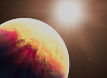
 JWST Watches HD 80606 bExoplanet Heat Up by 1,100 Degrees in Hours19 June 2026
 -
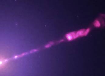
Chandra Captures Sharpest-Ever X-Ray View of M87 Black Hole Jet18 June 2026
-
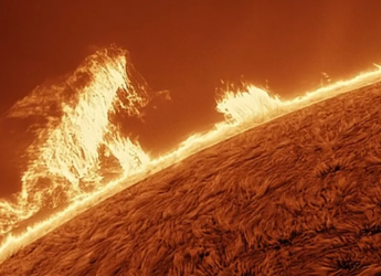
Astrophotographer Captures Giant Human-Shaped Solar Prominence8 June 2026
-
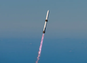
Blue Origin’s New Glenn Rocket Explodes During Pre-Launch Test in Florida29 May 2026
-
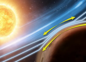
NASA’s MAVEN Detects Rare Solar Wind Effect in Mars Atmosphere28 May 2026
- Home
- Science
- Science News
- NASA's ICESat 2 Earth Tracking Satellite to Launch on September 15
NASA's ICESat-2 Earth-Tracking Satellite to Launch on September 15
By Indo-Asian News Service | Updated: 12 September 2018 17:18 IST

Photo Credit: NASA
Click Here to Add Gadgets360 As A Trusted Source

Advertisement
NASA is set to launch its Ice, Cloud and land Elevation Satellite-2, or ICESat-2 - that will track Earth's melting poles and disappearing sea ice - on Saturday.
The satellite with a three-year mission is scheduled to launch at 8.46am EDT on September 15, with liftoff aboard a Satellite Delta II rocket from Space Launch Complex-2 (SLC-2), the US space agency said in a blog post late on Tuesday.
ICESat-2 is the NASA's most advanced laser instrument - the Advanced Topographic Laser Altimeter System, or ATLAS.
It measures height by precisely timing how long it takes individual photons of light from a laser to leave the satellite, bounce off Earth and return to the satellite.
The satellite will provide critical observations of how ice sheets, glaciers and sea ice are changing, leading to insights into how those changes impact people where they live, NASA said.
ICESat-2's orbit will make 1,387 unique ground tracks around Earth in 91 days and then start the same ground pattern again at the beginning.
While the first ICESat satellite (2003-09) measured ice with a single laser beam, ICESat-2 splits its laser light into six beams making it better to cover more ground (or ice).
The arrangement of the beams into three pairs will also allow scientists to assess the slope of the surface they are measuring, NASA said.
Further, the ICESat-2 will zoom above the planet at 7 km per second (4.3 miles per second), completing an orbit around Earth in 90 minutes. The orbits have been set to converge at the 88-degree latitude lines around the poles, to focus the data coverage in the region where scientists expect to see the most changes.
All of those height measurements result from timing the individual laser photons on their 600-mile roundtrip between the satellite and Earth's surface - a journey that is timed to within 800 picoseconds, NASA said.
Comments
Get your daily dose of tech news, reviews, and insights, in under 80 characters on Gadgets 360 Turbo. Connect with fellow tech lovers on our Forum. Follow us on X, Facebook, WhatsApp, Threads and Google News for instant updates. Catch all the action on our YouTube channel.
Related Stories
Advertisement
Follow Us
-
 Moto G77 Power भारत में 50MP कैमरा, 7000mAh बैटरी के साथ लॉन्च, जानें
 -
Nothing Ear (3a) ईयरबड्स लॉन्च हुए खास ऑडियो स्नैपशॉट फीचर के साथ, जानें
-
₹2300 सस्ता मिल रहा Realme P3 Ultra 5G, Flipkart Goat Sale में आई गजब डील
-
क्या और महंगे होंगे मोबाइल-लैपटॉप? Samsung समेत कंपनियां बढ़ाएंगी RAM की कीमत
-
Asus ने लॉन्च किया 10W पावर वाला ब्लूटूथ स्पीकर, एडवांस फीचर्स से लैस, जानें कीमत
Advertisement
Popular on Gadgets
- Samsung Galaxy S26 Ultra
- Motorola Razr Fold
- ChatGPT
- OPPO Find N6
- Mobiles Under Rs. 40,000
- Vivo X300 Ultra
- Asus Zenbook S14
- iQOO 15
- Vivo X300 Pro
- Lenovo Yoga Slim 7i Aura Edition
- iQOO 15R
- Vivo X Fold 5
- Sony PlayStation 5
- HP OmniPad 12
- OnePlus Nord CE 6 Lite
- OnePlus Pad 4
- OPPO F33 Pro 5G
- Cryptocurrency
- HP OmniBook Ultra 14 (2026)
- iPhone 17
- Eureka Forbes AP 355 Room Air Purifier
- Latest Mobile Phones
- Compare Phones
Latest Gadgets
- Moto G77 Power
- Vivo G5z
- Vivo G5i
- Nothing Phone (4b)
- HMD Nokia 215 4G (2026)
- Vivo Y500 4G
- HMD Nokia 235 4G (2026)
- iQOO Z11i
- Asus Vivobook 15 (X1504MA)
- HP HyperX Omen 16 Valorant Limited Edition
- Red Magic Gaming Tablet 5 Pro
- Vivo Pad 5c
- Amazfit Cheetah 2 Ultra
- Amazfit Bip Max
- Sony Bravia 9 II
- Haier HQLED P7 Pro
- Acer Predator Atlas 8
- Asus ROG Ally
- IFB 1.5 Ton 3 Star Inverter Split AC (CI193GN22RGM3)
- IFB 2 Ton 3 Star Inverter Split AC (CI223GD32RGM3)

- About Us
- Sitemaps
- Feedback
- Archives
- Contact Us
- RSS
- Advertise
- Career
- Privacy Policy
- Ethics
- Editorial Policy
- Terms & Conditions
- Complaint Redressal
Download Our Apps
Available in Hindi
© Copyright Red Pixels Ventures Limited 2026. All rights reserved.


