
-
 iPhone 18 Pro, iPhone 18 Pro Max Alternatives: Pixel 11 Pro to Xiaomi 17 Ultra and More12 September 2026
 -
How to Factory Reset an Android Phone Safely: A Step-by-Step Guide12 September 2026
-
Samsung's Rumoured Android XR Smart Glasses With Colour Display: All You Need to Know11 September 2026
-
Google Makes It Easier to Switch Password Managers on Android: How to Transfer Passwords and Passkeys11 September 2026
-
Nothing Phone 2 to Stop at Android 16 as CEO Carl Pei Explains Update Decision9 September 2026
Instagram 3.0 brings Photo Maps and more to iOS, Android
By KS Sandhya Iyer | Updated: 17 August 2012 12:03 IST
Click Here to Add Gadgets360 As A Trusted Source

Advertisement
Instagram just got updated to let you take a trip down memory lane. Now the app wants you to know where you clicked your lovely pictures, besides merely adding effects.
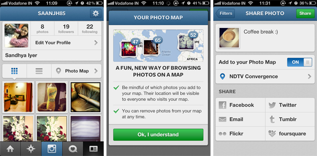
The photo-sharing app rolled out its latest update with a new feature called Photo Maps that displays geotagged photos of your location on a map. Users do have the option of disabling geotagging in case their concerned about privacy issues.
Once users update to version 3.0, a new Photo Map tab is added to their Profile page. Users navigating through Photo Map for the first time will be prompted to select photos that have been previously uploaded using geotagging. From then on, they will have the option to enable or disable the feature when posting new photos by turning on 'Add to your Photo Map'.
Users will always have the option to edit their Photo Map at a later time with the help of an Edit button. Users can also explore Photo Maps of their friends by visiting their profile. Photos appear in a stack when viewing them in a specific location. Tapping on a stack, displays photos in a grid.
Besides Photo Maps, other features include infinite scrolling, which means the Load More button is now gone. Photos now appear bigger in agrid-layout and there's a larger textbox for adding captions.
Instagram 3.0 is available for download on iOS and Android devices from iTunes and the Google Play store.
Here's a quick walkthrough video of the Instagram's new Photo Map feature.
Comments
Get your daily dose of tech news, reviews, and insights, in under 80 characters on Gadgets 360 Turbo. Connect with fellow tech lovers on our Forum. Follow us on X, Facebook, WhatsApp, Threads and Google News for instant updates. Catch all the action on our YouTube channel.
Related Stories



Advertisement
Follow Us




-

05:20
Samsung Galaxy Watch Ultra 2 Review: Is This the Best Android Smartwatch? -
07:01
Samsung Galaxy Z Fold 8 Review: Is This the Best Foldable Phone? -
06:39
Samsung Galaxy Z Fold8 Ultra Review: Cameras, Battery, Performance Tested -
04:33
[Sponsored] JBL Live 780NC: Great Sound, Perfect Comfort, Smart ANC & 80-Hour Battery -
12:04
[Partner Content] OPPO Reno16 Series Deep Dive: Built for Creators?
Advertisement
Popular on Gadgets
- Samsung Galaxy S26 Ultra
- Motorola Razr Fold
- ChatGPT
- OPPO Find N6
- Mobiles Under Rs. 40,000
- Vivo X300 Ultra
- Asus Zenbook S14
- iQOO 15
- Vivo X300 Pro
- Lenovo Yoga Slim 7i Aura Edition
- iQOO 15R
- Vivo X Fold 5
- Sony PlayStation 5
- HP OmniPad 12
- OnePlus Nord CE 6 Lite
- OnePlus Pad 4
- OPPO F33 Pro 5G
- Cryptocurrency
- HP OmniBook Ultra 14 (2026)
- iPhone 17
- Eureka Forbes AP 355 Room Air Purifier
- Latest Mobile Phones
- Compare Phones
Latest Gadgets
- iPhone Duo
- OPPO A7 Pro
- Huawei Mate XT 2 Ultimate Design
- Realme 16 Pro Harry Potter Edition
- Samsung Galaxy A07s
- Huawei Pura X View
- Tecno Camon Slim 5G
- iQOO Z11xa
- Acer Aspire G 3D 16
- Acer Swift Air 16 (2026)
- Infinix Xpad 30 Pro
- Lenovo Yoga Tab Gen 2
- Apple Watch Ultra 4
- Apple Watch Series 12
- Haier M70 Mini LED 65-inch
- Xiaomi TV FX Mini LED 65
- Acer Predator Atlas 8
- Asus ROG Ally
- Blue Star 1.5 Ton 5 Star Inverter Split AC (IE518ZNURS)
- Blue Star 2 Ton 3 Star Inverter Window AC (WIE324L)

- About Us
- Sitemaps
- Feedback
- Archives
- Contact Us
- RSS
- Advertise
- Career
- Privacy Policy
- Ethics
- Editorial Policy
- Terms & Conditions
- Complaint Redressal
Download Our Apps
Available in Hindi
© Copyright Red Pixels Ventures Limited 2026. All rights reserved.