- Home
- Internet
- Internet News
- Google updates View community to allow users to create their own Street Views
Google updates View community to allow users to create their own Street Views

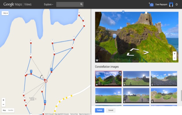
As per Google, users can now take the help of a new feature in Views community to connect their photo spheres to create a 360 degree virtual tour of a place and share them on Google Maps. Much like the Street View, users can embed the interactive viewer on their website or create apps with it using the Google Maps API.
Google has also detailed the process for building personalized street view maps. Start by creating a photo sphere using an Android smartphone or a DSLR, and sharing it on Views; next users need to select the photo spheres from their profiles and use the Google's new feature or tool to connect (pictured above) them together, Google calls the 360 degree views as constellations. Once the photo spheres are connected and published, users can navigate between them on Google Maps, just like one can do in Street View.
Google Maps & Photo Sphere, Product Manager Evan Rapoport said on the Google Maps blog post, "We are excited to see the different types of Street View experiences that everyone will contribute. For example, this feature can now enable environmental non-profits to document and promote the beautiful places they strive to protect. It also opens up a new tool for photographers to showcase diversity in a specific location -- by times of day, weather conditions or cultural events -- in a way that Street View currently doesn't cover."
Earlier, Google Maps was updated with new features and tools based on feedback from its users, namely: directions for multiple destinations; displaying relevant itinerary data within maps itself, and, displaying upcoming events data for venues.
Catch the latest from the Consumer Electronics Show on Gadgets 360, at our CES 2026 hub.
Related Stories
- Samsung Galaxy Unpacked 2025
- ChatGPT
- Redmi Note 14 Pro+
- iPhone 16
- Apple Vision Pro
- Oneplus 12
- OnePlus Nord CE 3 Lite 5G
- iPhone 13
- Xiaomi 14 Pro
- Oppo Find N3
- Tecno Spark Go (2023)
- Realme V30
- Best Phones Under 25000
- Samsung Galaxy S24 Series
- Cryptocurrency
- iQoo 12
- Samsung Galaxy S24 Ultra
- Giottus
- Samsung Galaxy Z Flip 5
- Apple 'Scary Fast'
- Housefull 5
- GoPro Hero 12 Black Review
- Invincible Season 2
- JioGlass
- HD Ready TV
- Laptop Under 50000
- Smartwatch Under 10000
- Latest Mobile Phones
- Compare Phones
- OPPO Reno 15 FS
- Red Magic 11 Air
- Honor Magic 8 RSR Porsche Design
- Honor Magic 8 Pro Air
- Infinix Note Edge
- Lava Blaze Duo 3
- Tecno Spark Go 3
- iQOO Z11 Turbo
- Lenovo Yoga Slim 7x (2025)
- Lenovo Yoga Slim 7a
- Lenovo Idea Tab Plus
- Realme Pad 3
- Moto Watch
- Garmin Quatix 8 Pro
- Haier H5E Series
- Acerpure Nitro Z Series 100-inch QLED TV
- Asus ROG Ally
- Nintendo Switch Lite
- Haier 1.6 Ton 5 Star Inverter Split AC (HSU19G-MZAID5BN-INV)
- Haier 1.6 Ton 5 Star Inverter Split AC (HSU19G-MZAIM5BN-INV)


![[Sponsored] Haier C90 OLED TV | Dolby Vision IQ, 144Hz OLED and Google TV in Action](https://www.gadgets360.com/static/mobile/images/spacer.png)


